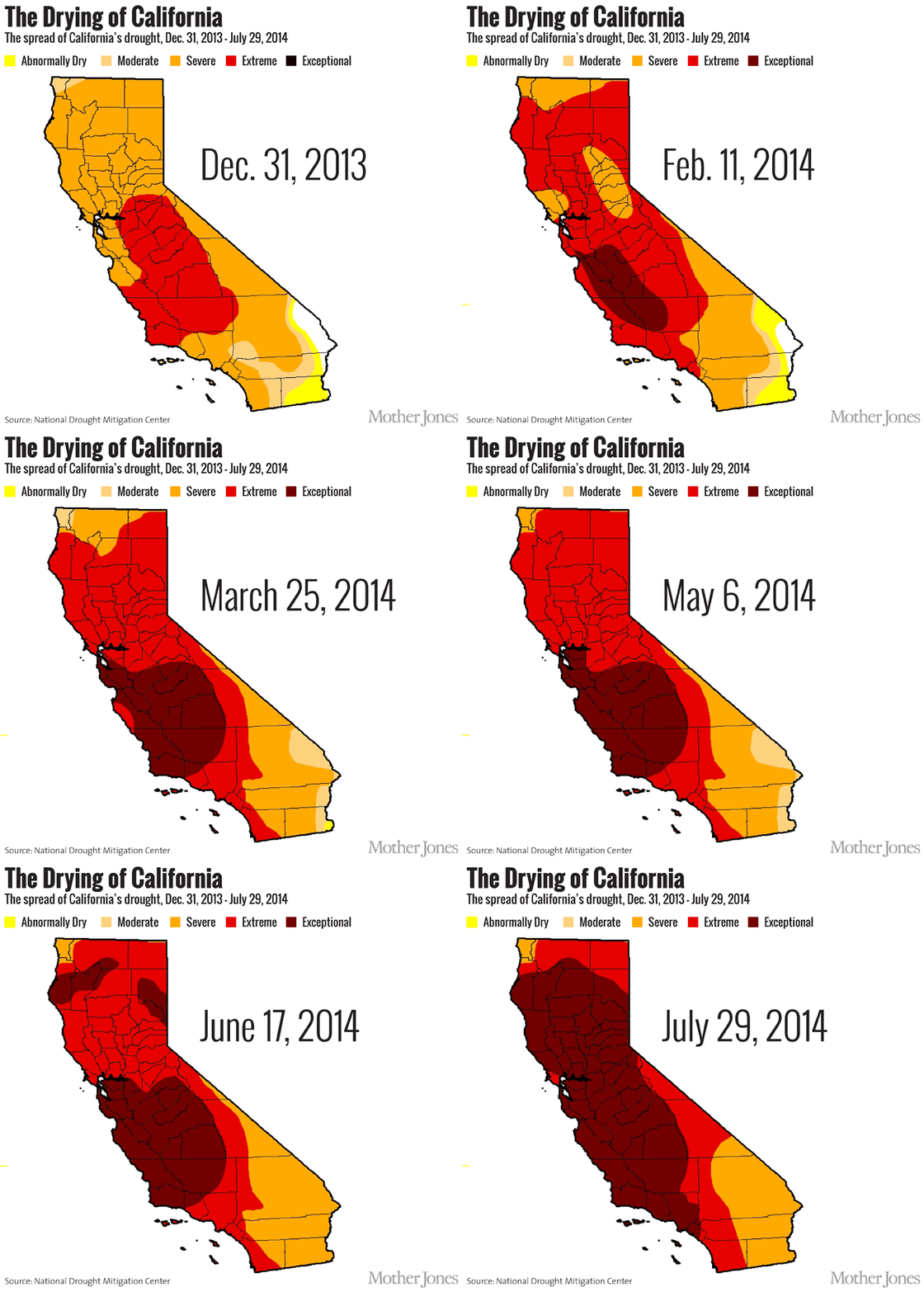
California’s rainy season generally starts in early March and lasts until late October, but for the past four years it seems as though we have been stuck in a perpetual state of April- September. Across the state, lawns are browning, lakebeds are drying, and snow packs are melting at a concerning rate.
The first response to these observations would be to point the finger at climate change, and this is certainly a factor in the severity of the drought. The warm weather, causing precipitation to fall in the form of rain rather than snow, has impacted the accessibility of water statewide. Although rain is a good thing, it poses storage and distribution issues. California has a Mediterranean climate meaning wet winters, dry summers, and snow packs, which accumulate during the cold months. The snow packs gradually melt into useable water during the heat of the summer, which is vital for water accessibility in this type of climate. However, a report released by the National Oceanic and Atmospheric Association in 2014 attributes the drought not to human-induced climate change, but to a high-pressure atmospheric ridge off of the West Coast that is diverting precipitation north to Alaska and British Columbia.

Scientists are studying the resilience of this ridge, and what factors contribute to the extremity and likeliness of ridges formation. A study published in September 2014 argues that the formation of a ridge is much more probable with the current concentration of greenhouse gasses in the atmosphere, directing the causation of the California drought back to humans and their effect on climate change. The ridge also gives rise to a new problem: it is diverting cold air away from the ocean, forming an area of warm water off of the West Coast. This area, “The Blob”, dominates a large geographical landscape, and the air flowing from the ocean over the Blob is warm, restricting precipitation in California.
It’s no surprise that many Californians are rejoicing as meteorologists predict that the weather system known as El Niño will likely bring precipitation to the parched state. However, this widespread excitement is largely based on a number of misunderstandings about exactly what El Niño is and its ability to reverse the effects of California’s severe drought.
El Niño is part of a larger weather system called the El Niño Southern Oscillation. El Niño Southern Oscillation is an OCT variation in ocean temperatures and wind patterns in and over 2015 the Pacific Ocean. El Niño and its counterpart, La Niña, are weather patterns that occur as a result of these variations. When the winds over the Pacific that normally travel East to West die down, warm water from the Western Pacific travels to the Eastern Pacific and El Niño occurs. When cold water from the bottom of the ocean gets pushed upwards, La Niña occurs. The two alternate with one or the other occurring every three to seven years.
A common misconception is that El Niño is coming this winter or that it might not come at all. In fact, El Niño is already here. The National Oceanic and Atmospheric Administration (NOAA) first declared the presence of the El Niño weather pattern in March of this year when they first concluded that increased ocean temperatures were consistent enough to be indicative of the occurrence of El Niño. In a report released on September 7th of this year the NOAA’s Climate Prediction Center (CPC) stated that, “There is a greater than 90% chance that El Niño will continue through Northern Hemisphere winter 2015- 16.”
However, even if El Niño does continue into this winter it is unlikely that it will reverse the effects that four years of drought have had the groundwater and mitigate subsidence.
What California really needs is snow in order to see a significant reversal of the effects of the drought. California’s biggest reservoirs, the ones that major cities and large farms get their water from, are fed from the snowpack in the Sierras as it melts. Snowpack is better than rainwater because it provides a steady source of runoff water over a longer period southern Lake County, where the Valley Fire recently raged through 76,000 acres of land, or the Rough Fire in Fresno County which as of October 2, 2015 is 95% contained and has swept through 151,00 acres.
Although there is little we can do to prepare for El Niño; we do need to continue our defense against drought. The California Government is already taking strides to cut back on water usage statewide. In May 2015, Governor Jerry Brown ordered a 25% reduction of California water use, as well as more specific restrictions based on regional water use. For example, some of the highest cutbacks in the Bay Area have been in Hillsborough and Brentwood, while San Francisco has only been asked to cut back by 8 percent.
To discourage water waste, the Governor has also been encouraging fines, and although there have been fines handed out for up to $200, authorities are being urged to issue fines up to $10,000 to water-wasting cities, districts or even private companies, if necessary.
Projects proposed to share California’s water supply throughout the state include Brown’s Sacramento-San Joaquin proposal. But as we make plans to provide water for all of the state, despite decreased supply we have to plan with awareness of the long-term impacts of short-term solutions.
Whether El Niño turns out to give us the hoped for heavy rains this winter, we need to realize that it could have some damaging effects and it will most likely not make a huge dent in our drought recovery process. Heavy rains would be a temporary relief and we as a community need to continue to be mindful and conserve our water usage.


